 Indonesia
Assessing the Impact of Climate Change for Local Adaptation Planning in the Republic of Indonesia
1. Introduction
The Indonesian government published the National Action Plan for Climate Change Adaptation (Rencana Aksi Nasional Adaptasi Perubahan Iklim or RAN-API) in 2014. The Ministry of the Environment of Japan (MOEJ) and the Ministry of National Development Planning, Indonesia (BAPPENAS) are cooperating on assessing the impact of climate change for local adaptation planning in the Republic of Indonesia. The cooperation is being implemented in line with the RAN-API and in close collaboration with relevant Ministries, local Universities, and donors including Japan International Cooperation Agency (JICA).
Science-based climate impact assessment has been conducted based on this cooperation, and policy recommendations for mainstreaming adaptation into development plans have been developed for North Sumatra, East Java, and Bali provinces (Figure 1) for certain target sectors (e.g., agriculture, heat stress, waterborne diseases, and oceans and fisheries). The University of Tokyo has taken the lead on this project, in collaboration with Japanese project consortium members, Ibaraki University, the National Institute for Environmental Studies, and Nippon Koei Co. Ltd. A simplified explanation of the project is described as below.

2. Methodology
Various stakeholders in the central and regional governments were included during the initial stages of the project to understand issues and to consider the necessity and feasibility of adaptation options (Figure 2). Target regions were selected for impact evaluation based upon the results of workshops, and the sectors expected to be impacted most severely by climate change in North Sumatra Province and East Java Province are heat stress, waterborne disease, and oceans and fisheries.

To assess climate change impacts, General Circulation Models (GCMs) of future climate projections were used as input data for the impact model. High performance GCMs were selected and the GCMs output bias in the compared observations were corrected (Figure 3). Exceptionally, 4 models (BNU-ESM, CNRM-CM5, IPSL-CM5A-LR, IPSL-CM5A-MR) were used in the impact assessment of Agriculture sector in all target regions.

3. Results
(1) Agriculture
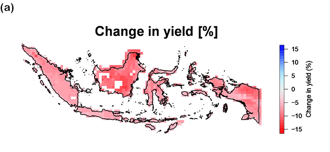
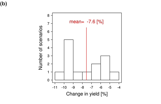
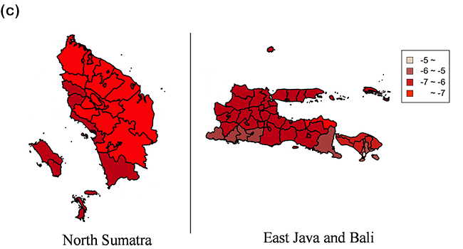
In this study, rice yields were assessed with a crop growth model for paddy rice (Masutomi et al., 2016a, 2016b) using projected climate conditions from GCMs. After running the crop growth model using future projection data by selected GCMs (scenarios), a negative impact (decrease) in average rice yield, relative to the historical yield, was predicted (Figure. 4).
Chamber experiments were conducted in which saplings of the Indonesian rice variety Ciherang were exposed to high temperatures (Figure 5). Results showed that the grain size decreased at higher temperatures (rice yield decreased) and an increase of the chalky part of the grain was observed (i.e., the head rice yield decreased).
Through dialog with local stakeholders, high priority adaptation measures were identified. They included changing the variety of rice used, introducing an early warning system, changing the postharvest system, and changing agricultural management as well as implementing other highly feasible adaptation measures (Figure 6).


(2) Heat stress
The impacts of climate change on heat stress, which occur when the body is unable to regulate its temperature, were assessed. Heat stress is most often caused by heat exposure, crowded conditions, lack of air flow, and dehydration. The elderly, infants and young children, people taking certain medications, outdoor workers, and those living without air conditioning are the most susceptible.
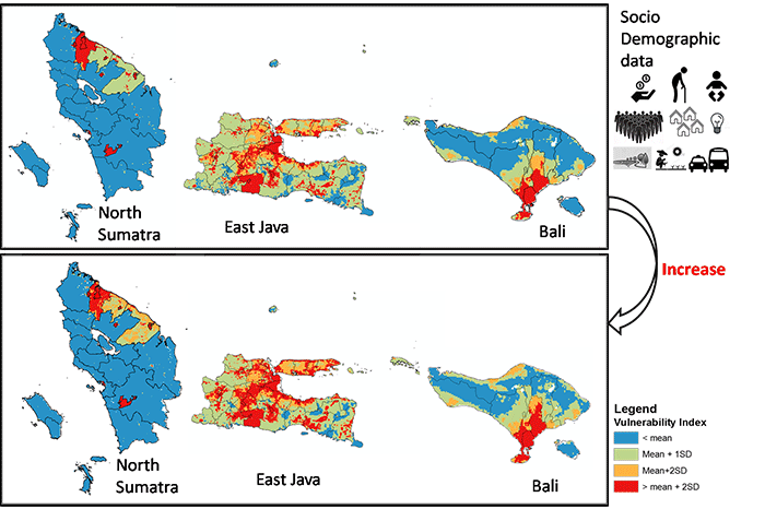
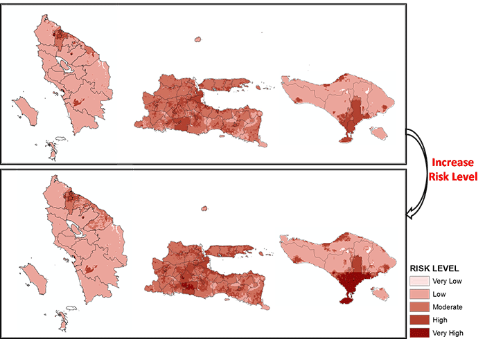
The impact of environmental heat on humans living in cities is evaluated using the Heat Stress Index (calculated using land surface heat and air temperature) and the Vulnerability Index (a function of exposure, sensitivity, and adaptive capacity). Comparing the baseline years (1981-2005) and the future years (2018-2024), the vulnerability index and risk level increased throughout the target study regions (Figure 8 and Figure 9). Adaptation options were discussed among stakeholders in a manner similar to that used in the discussion on agriculture. Raising citizen awareness of heat risk, raising the awareness of related agencies, citizen and agency preparedness, and increasing the green space and water in the urban landscape were categorized as high priorities and highly feasible adaptation measures (Figure 10).


(3) Waterborne disease
The risk of infection with the norovirus, based on exposure to floodwater, was investigated in Medan in North Sumatra and Surabaya in East Java. The risk assessment combines different layers of information, such as inundation maps, population distributions, norovirus concentrations, and exposure assessment (Figure 11).
Figure 12 shows the number of people infected with norovirus annually in each area. It was predicted this number would increase from 35,000 (2015) to 61,000 (2030) in Medan, and from 90,000 (2015) to 130,000 (2030) in Surabaya.
As above, several adaptation options were categorized into high priority and highly feasibility measures. These are depicted in Figure 13.


(4) Oceans and fisheries
Sea level rise was studied using satellite and observational data. It was predicted that after 100 years, sea levels could rise 50 cm around the North Sumatra region. Numerical simulation shows that 11.9 km2 to 63.8 km2 of coast could potentially be lost with inundation of 1 to 2 m, respectively (Figure 14 and Figure 15).
This shows that the coastal areas of eastern North Sumatra are vulnerable to sea level rise. Potential threats associated with sea level rise include: i) erosion and degradation of shoreline, ii) stronger storm surges that could further damage infrastructure, rice fields, ponds, farms, and iii) permanent flooding of coastal lowlands.
In addition, numerical model experiments were used to investigate climate change and the impacts of human activity on fisheries in the Java Sea. A three-dimensional coupled physical-biogeochemical model was developed to investigate the influence of physical processes on biogeochemical cycles in the Java Sea. Preliminary results show the impact on fish production in Sumatra sea (571,572 t) and Java sea (712,573 t) in 2025 and 2050. Catch control was categorized as a high priority, highly feasible adaptation measure (Figure 16).


References
- Masutomi, Y., Ono, K., Mano, M., Maruyama, A., and Miyata, A.: A land surface model combined with a crop growth model for paddy rice (MATCRO-Rice v. 1) - Part 1: Model description, Geosci. Model Dev., 9, 4133-4154, doi:10.5194/gmd-9-4133-2016, 2016.
- Masutomi, Y., Ono, K., Takimoto, T., Mano, M., Maruyama, A., and Miyata, A.: A land surface model combined with a crop growth model for paddy rice (MATCRO-Rice v. 1) - Part 2: Model validation, Geosci. Model Dev., 9, 4155-4167, doi:10.5194/gmd-9- 4155-2016, 2016.
- The University of Tokyo, National Institute for Environmental Studies, Ibaraki University, Meiji University, NIPPON KOEI Co. Ltd, Udayana University and Bogor Agricultural University; Climate Change Impact Assessment for Local Adaptation Planning in the Republic of Indonesia, Ministry of Environment, Japan, 2017.

