Mangroves reduced damage to earthen embankment
- Sundarban, India
ABOUT THIS ISSUE
The network of earthen embankments that make the Indian Sundarban delta are highly vulnerable to storm surges
SOLUTION
It was evident after cyclone Aila, embankments shielded by mangroves suffered less damage, resulting in the adoption of protective plantations in front of embankments
Embankments of Sundarban delta
The Sundarban delta in India and Bangladesh is one of the most densely populated deltas in Asia and spreads across multiple small riverine islands, crisscrossed by large rivers and creeks. Nearly 70% of the existing land of the Indian Sundarban delta is submergible under high tide, but the 3,500 km long network of marginal earthen embankments makes human habitation possible in these extremely low-lying deltaic islands. These embankments were constructed more than 100 years ago during the British colonial regime. While they have been maintained from time-to-time, these fragile earthen embankments have not undergone any major structural changes despite being the critical coastal infrastructure that determines the safety and wellbeing of communities. These structures are particularly susceptible to high winds and storm surges and, as with many other reclaimed lands across the world, breaching of embankments leads to instantaneous flooding. The network of earthen embankments underwent a critical breakpoint when cyclone Aila hit the delta on the 25th of March 2009 with a wind speed of 100–110 km per hour. The storm overlapped with the morning high tide and generated a storm surge of more than 3 meters above the High Tide Line (HTL); higher than the maximum height of most of the earthen embankments. The entire network of embankments, especially those in the northeastern area lying in the path of the storm, were severely damaged.
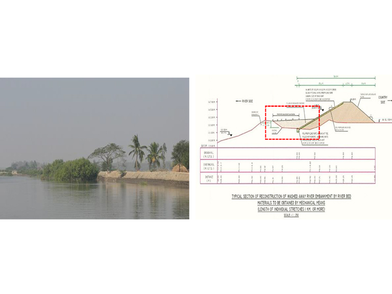
(Right) Section of proposed river embankments with mangrove plantation zone marked in red.
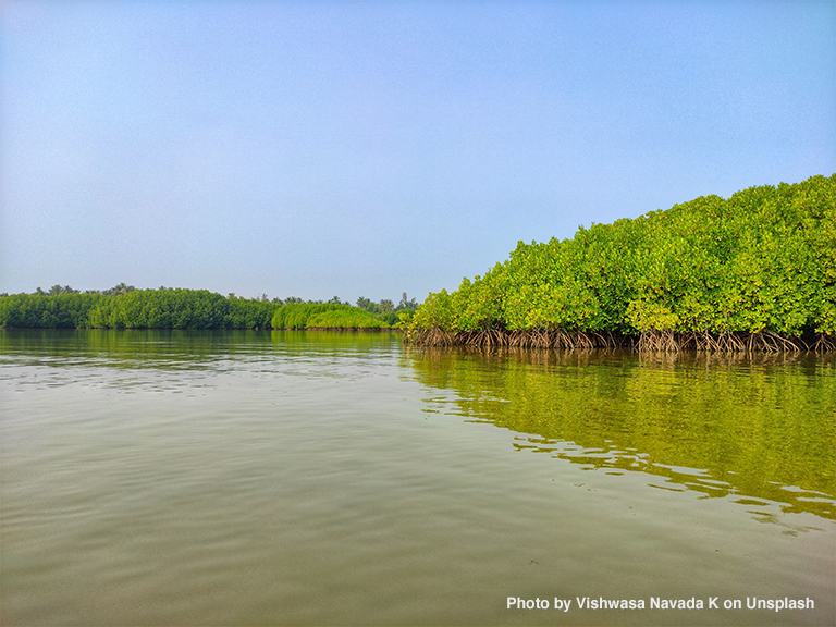
Mangroves shield the fragile embankment
During cyclone Aila, 177 km of the earthen embankment were completely washed away, and 601 km were severely damaged. Despite widespread damage to the earthen embankment network, mangroves protected embankments in many places (Figure 1, left); thus, protecting and safeguarding communities. But the nearly 2,000 km long embankment did not have a continuous protective plantation barrier. Following the cyclone, a massive reconstruction project, the Aila embankment reconstruction project, was launched and was jointly supported by the federal and provincial governments. This project helped to rebuild a large part of the age-old embankment network.
Implementing an NbS in the Aila embankment reconstruction project
Mainstreaming the NbS
The embankment reconstruction project proposed incorporating the ecosystem services provided by the rich mangrove forests of the Sundarban delta. Mangroves grow naturally in the delta with little to no assistance, so it was decided to develop a protective buffer of mangrove forests along the embankment network, ranging 10–15 meters in width on the river/seaside as shown in Figure 1 (right). Reconstruction plans were developed with full technical details for plantation, including the choice of species and plantation method.
Engagement of the community through the livelihood support mission
Cyclone Aila led to the loss of livelihood, particularly due to the salinization of agricultural land. Thus, the local government adopted a project, titled the Green Sundarban project, to generate livelihood from mangrove plantations for local communities, especially women. Funds from the Mahatma Gandhi National Rural Employment Guarantee Act 2005 (MGNREGA) were mobilized for this purpose. The Green Sundarban project (2012–17) represented a win-win situation for the environment, alternative livelihood development, embankment reconstruction, and community empowerment, which ultimately helped develop small scale plantations across the delta.
Location
References
- DasGupta, R (2016). Enhancing Coastal Community's Disaster and Climate Resilience in the Mangrove Rich Indian Sundarban.
- DasGupta, R., Shaw, R. & Basu, M. (2019). Implication and Management of Coastal Salinity for sustainable community livelihood: a case study from the Indian Sundarban Delta. In Coastal management (pp. 251-269). Academic Press.