AP-PLAT Conducted a Field Assessment to Evaluate the Need for Early Warning System Support in Nepal
| Event | Field Assessment and Meetings with Relevant Government Agencies and Focal Group Discussion with Disaster Impacted Communities in Nepal |
|---|---|
| Date | 7-12 December 2025 |
| Location | Nepal |
| Organizers | Ministry of the Environment, Japan (MOEJ) Institute for Global Environmental Strategies (IGES) |
OVERVIEW
As part of the capacity-building program in Nepal, AP-PLAT conducted a community-level disaster preparedness assessment in the Upper Sunkoshi River Basin. Consultations were held with national government agencies, municipal authorities, and disaster-prone communities across Melamchi and Bhotekoshi municipalities. The objective was to evaluate the current status and gaps in Early Warning Systems (EWS) and cascading risk monitoring.
Three key activities were conducted:
- High-level consultations with the Climate Change Management Division (CCMD) and Department of Hydrology and Meteorology (DHM).
- Municipal-level engagement with Bhotekoshi Rural Municipality officials.
- Community-level focus group discussions (FGDs) in Chanaute and Gyalthum (Melamchi) and in Eco Village and Jambu (Bhotekoshi).
The assessment aimed to understand challenges and opportunities in strengthening localized early warning systems and mainstreaming anticipatory action.
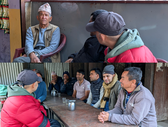
In the field visit to Nepal, two focus group discussions (FGDs) were conducted. The FGDs were conducted in Chanaute and Gyalthum of Melamchi Municipality, and another in Eco Village and Jambu of Bhotekoshi Rural Municipality. The FGDs were attended by disaster-affected local residents, including community elders, women, and farmers. The objective of the field visits and FGDs was to understand the community’s disaster exposure, the effectiveness and gaps in the current early warning systems (EWS), the use of traditional knowledge, and the local response and recovery mechanisms, particularly in areas vulnerable to landslides and flash floods.
The discussions focused on participants’ socio-economic conditions, historical exposure to compound disasters, access to early warnings, indigenous risk indicators, and the mechanisms by which warnings are, or are not, disseminated. Special attention was given to the community’s recollection of loss events, existing shelter and evacuation provisions, training access, and perceptions of government response. These sessions aimed to identify capacity-building needs for future preparedness and recovery, and to inform the design of localized interventions to reduce disaster risk and loss and damage in future events.
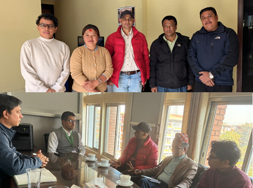
AP-PLAT also met with Climate Change Management Division (CCMD), Department of Hydrology and Meteorology (DHM), and Local government representatives from Bhotekoshi Municipality to gather insights on strengthening localized Early Warning Systems (EWS) and anticipatory actions in disaster-prone areas of Nepal. Emphasis was placed on identifying opportunities for coordination across government, research institutions, and development partners.
KEY FINDINGS
- DHM has significantly improved hydromet coverage, but cascading hazard modeling and sediment data remain gaps. Current EWS are limited to single hazards. DHM is interested in Japanese modeling techniques (e.g., Tank Model), low-cost sensors, and AI-enhanced forecasting.
- Government support has focused more on infrastructure repair than livelihood recovery. Respondents in Chanaute and Gyalthum reported minimal compensation for lost farmland and lack of long-term livelihood restoration assistance.
- Local communities remain exposed to cascading hazards with insufficient or informal warning mechanisms. In Chanaute and Jambu, community members relied on visual cues and verbal communication for evacuation. Sirens and communication protocols were installed only after major disasters.
- High demand exists for integrating indigenous knowledge into DRR systems. Both Chanaute and Jambu communities highlighted traditional indicators (e.g., tree bending, fish migration) that were once widely used but are now sidelined by one-off technical interventions.
- Community preparedness has declined due to lack of refresher training and outmigration of trained volunteers. In Gyalthum, while sirens and risk communication tools exist, few residents are confident in emergency response actions due to skill attrition.
- Structural threats persist in highly exposed zones like Eco Village. The landslide-prone area is under continuous geological motion with visible infrastructure damage. No relocation plan or response mechanism exists despite the proximity to critical roads and trade routes.
- Local government in Bhotekoshi is active in policy and DRR training, but uneven intervention exists. While DRR training and evacuation planning have been undertaken, landslide-prone areas like Hile lack active intervention or dedicated support.
(Posted : 05/Jan/2026)
