 Asia - Japan
Challenge
Protected forests help preserve and manage natural environments, wildlife, and genetic resources. However, a lack of connectivity between the protected areas limits interactions among wildlife populations and constrains biodiversity conservation.
Solution
In Japan’s national forests, “Green Corridors” are designated by linking existing protected forests. These corridors aim to restore continuous natural forests and enable ecological interactions among wildlife populations.
Overview
The Green Corridor initiative is a forest ecosystem conservation measure implemented in national forests by the Forestry Agency of Japan. The initiative aims to conserve biodiversity by connecting existing protected forests and restoring continuous natural forest areas. Through this approach, the initiative seeks to secure wide-ranging connections among habitats of wildlife and contribute to the conservation of species and genetic resources.
This article introduces the Green Corridor initiative as implemented in the Tohoku region, focusing on the Ou Mountain Range.
Background: Protected forests in national forests
In Japan’s national forests, protected forests have long been designated to maintain primary natural environments, preserve and manage wildlife and plant species, and genetic resources. These protected forests include valuable forest ecosystems and habitats.
While these protected forests have played an important role in conservation, ensuring connections among habitats across a wider area has been identified as necessary for supporting interactions among wildlife populations and enhancing biodiversity conservation.
Based on this background, guidelines for the designation of Green Corridors in national forests were established. Historically, the origin of the Green Corridor concept dates back to 1995, when Aomori Forest Regional Office formulated the “Natural Forest Zone Concept across the Ou Mountain Range.
Designation of Green Corridors
To address this need, the Forestry Agency has designated Green Corridors by linking existing protected forests. The purpose of Green Corridors is to restore continuous natural forests and secure broad ecological connections for wildlife that originally inhabit these areas.
Green Corridors are designated based on geographical features such as ridges and valleys, with careful consideration for wildlife movement. In selecting corridor routes, consideration is given to forest conditions, terrain, and existing land use in the surrounding area.
Since 2000, five Green Corridors have been designated in the Tohoku region, covering approximately 179,000 hectares with a total length of about 920 kilometers. Major corridors include the Ou Mountains, Kitakami Highlands, Shirakami–Hakkoda, Chokai–Asahi–Iide–Azuma, and Hachimantai–Taiheizan.
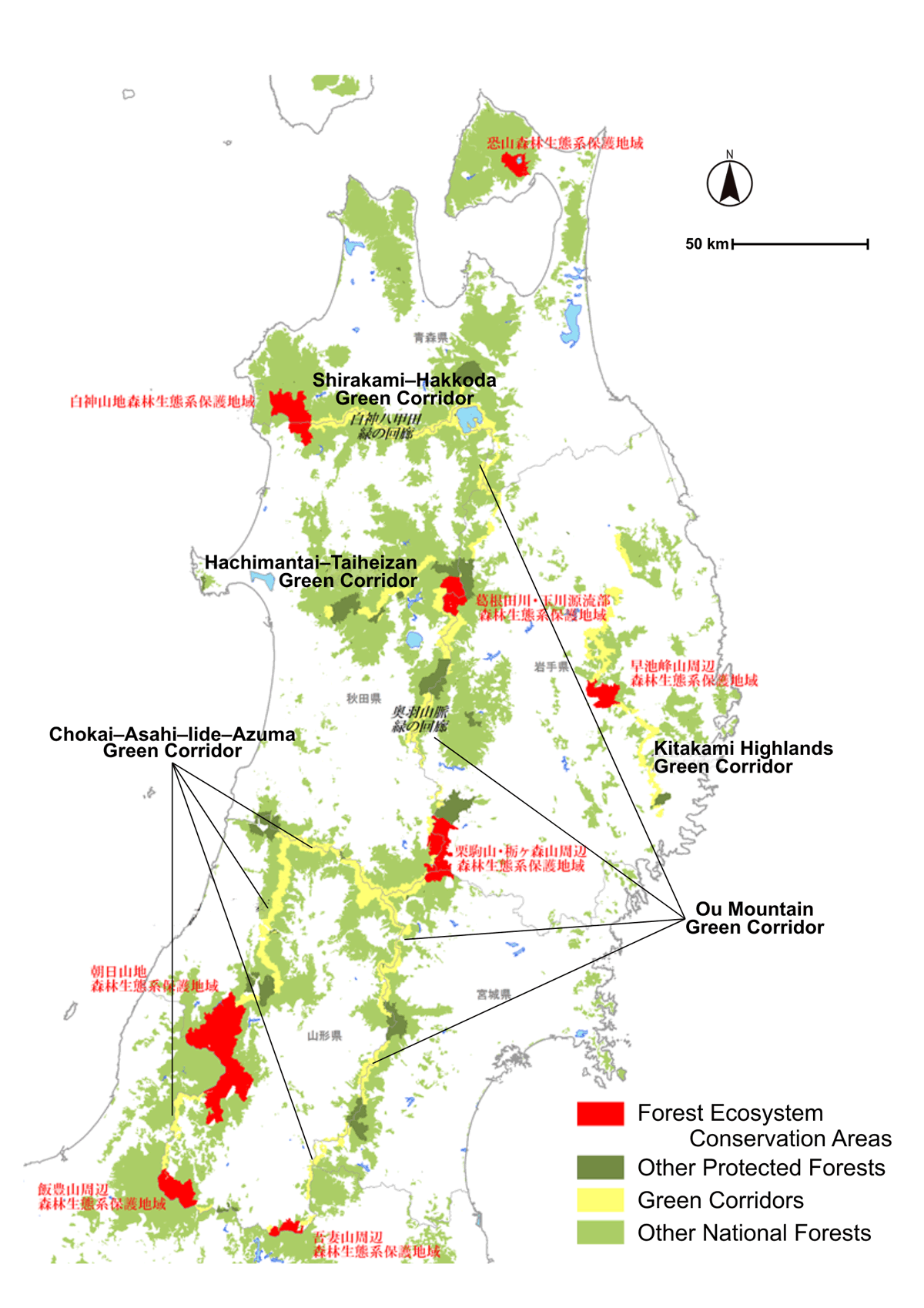
Green Corridor network map (adapted from the Tohoku Regional Forest Office, Forestry Agency of Japan). The map shows the distribution of Green Corridors linking protected forest areas in national forests of the Tohoku region, designed to maintain ecological connectivity for wildlife.
Management within Green Corridors
Forest management within Green Corridors is conducted with careful consideration for wildlife habitats. Logging activities are carried out in accordance with forest function classifications, avoiding excessive impacts on ecosystems. Management practices aim to maintain diverse forest structures and avoid bias toward specific tree species.
Special attention is given to preserving large and old trees, standing dead trees, and fallen logs where they do not pose safety concerns, as these features are important for wildlife habitats. Regeneration and tending work are implemented flexibly, with attention to understory vegetation and food resources for wildlife. Within Green Corridors, plantation forests are gradually guided toward mixed forests dominated by broadleaf species, aiming for the long-term formation of natural forests.
Monitoring after designation
Monitoring is conducted even after Green Corridors are designated. Monitoring includes forest surveys (tree species, stand age, vegetation) and wildlife surveys using direct observation, traces, and sensor cameras, and collections of sensor camera photographs have been made publicly available. These data and monitoring results are shared with relevant prefectural departments, universities, and research institutions, as needed. These efforts support appropriate management of Green Corridors.
In addition, Green Corridors are utilized for patrol activities to observe wildlife conditions. The Green Corridor initiative is one example of forest and forestry measures implemented by the Forestry Agency in Japan’s national forests.
Project details
| Project title | Green Corridor Initiative in National Forests |
|---|---|
| Implementing organization | The Tohoku Regional Forest Office |
| Target areas | National forests in Tohoku, Japan (excluding Fukushima Prefecture) |
| Year started | 2000~ |
Acknowledgements
This article is based on information published by theTohoku Regional Forest Officeof the Forestry Agency of Japan, regarding the designation and management of Green Corridors in national forests.
Related information
- Tohoku Regional Forest Office: Green Corridors (in Japanese) https://www.rinya.maff.go.jp/tohoku/sidou/kairou.html
- Tohoku Regional Forest Office (March 2022): Ou Mountain Range Green Corridor Policy (in Japanese, PDF)
https://www.rinya.maff.go.jp/tohoku/sidou/attach/pdf/kairou-6.pdf - Tohoku Regional Forest Office: Ou Mountain Range Green Corridor Leaflet (in Japanese, PDF) https://www.rinya.maff.go.jp/tohoku/policy/business/management/hozen/pdf/ooukaiou.pdf
 DISCOVER MORE

